News Weather Why will it be colder in the plains than in the mountains in the coming days?
By Cyril BONNEFOY, meteorologist
The cold has been back for a few days and you've probably noticed it, but it's not the case for everyone, especially in the mountains. La Chaine Météo returns to this thermal inversion phenomenon that you will be able to witness in the coming days.
Check the weather forecast for your cityWhy will it be colder in the plains than in the mountains in the coming days?An anticyclonic blocking situation was set up this week in the country. A powerful anticyclone at 1043 hPa centered on the north of France thus obstructs any disturbance. The consequences in terms of temperatures are however very different depending on the plains, valleys and mountains.
An anticyclone loaded with subtropical air aloft
Like what happened 15 days ago, a new anticyclone is rising over our country and carrying air of subtropical origin aloft. However, this mild air will not reach the temperature levels of the end of December or the beginning of January. Indeed, two weeks ago, temperatures had reached 15 to 18°C at 1500 m in the south of the country. This time, we will be around 5 to 8°C, which is still high for the season. This is why, as of this Wednesday, the temperatures had sometimes become positive again in certain mountain resorts. So, if you plan to ski for the next few days, the conditions will be rather pleasant with few frosts in the morning, except in certain cold holes, and the values will be clearly positive in the afternoon in the 1500-2000 m range. The 0°C isotherm should even rise above 3000 meters on Friday in the Northern Alps. Don't worry, the snow won't melt too much, due to the dry weather and light frosts observed on the ground during the night.
Credit: The Weather ChannelAn anticyclone producing cold low level air

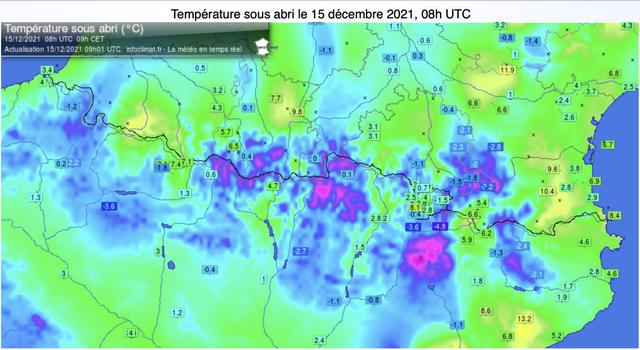
If this anticyclone is accompanied by mild air at altitude, it is quite the opposite in the lower layers since it produces cold air. This is a classic case in winter, areas of high pressure stick cold air in the first layers of the atmosphere. Clear skies under an anticyclone promote radiative cooling. When night falls, the little heat (energy), received during the day by the ground, is returned to the atmosphere, since there is no cloud cover to retain it. This is how the plains and valley bottoms cool very quickly. In recent days, you have been able to feel a clear cooling of the bottom of the air with almost generalized frosts from the northeast to the southwest and even sometimes as far as Provence. The minimums fell between -3 and -7°C on average in these plain areas. Note that with the drop in temperature, the humidity in the lower layer tends to condense and form patches of fog. In this case, it is at the top of the fog that you will be able to observe the lowest temperatures. The sun which overhangs the fog, causes its evaporation. This physical phenomenon consumes energy and therefore produces cold. Thus, in this specific case with fog, the strongest frosts are observed not in the plains, but on the first slopes of the mountains.
Credit: The Weather ChannelThermal deficit in the plain for the next few days and surplus in the mountains
This weekend, you will keep your warm clothes in the flat areas and in the valleys. Minimum temperatures will continue to drop with severe frosts at times (
A winter anticyclone can thus produce its own cold air in the low layer while at altitude, it carries much milder air. These situations give rise to thermal inversions between cold and sometimes gray weather in the plains and sunny and mild weather in the mountains. This is the program for the next few days, and this situation could repeat itself next week.


